Nine Wells   -  Pembrokeshire, Wales
 
www.Nine-Wells.org.uk


Nine Wells Area


What's in the name?

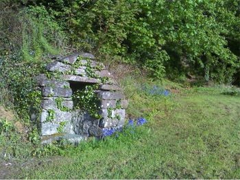
On first sight, one could be forgiven for thinking that the covers on either side of the road are the nine wells. However these 'covers' from the former St Davids waterworks were built at a place called 'Nine Wells' in 1899.

Hence the name probably derives from the nine wells in the area.

These roughly cover the area of the water basin of the stream that flows through Nine Wells i.e. reaching up to Llanruidion, Pen Pant, Croftufty, Picket Post, and to Porth-y-Rhaw on the coast. Within this area are the 9 wells and is the area covered by this web site.


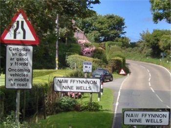
Approaching the Nine Wells bend from Solva

  Map from 1975 of Nine Wells area


The 44 (circled red) shows an old bench mark -
at that point the ground is exactly 44 feet above sea level.
 

The Nine Wells

1  communal well at Nine Wells
  
2  private well at Delfryn
 
3  private well at Croftufty
 
4  private well at the Picket Post
 
5  private well at Mutton Farm (Pink House)
 
6  communal well at the Mill, Porth-y-Rhaw
 
7  communal well along the coast
 
8  ?
 
9  ?


'Boundary of St Davids Parish' stone

The stream forms the boundary between the Solva and St Davids parishes, from the main road down to the sea at Porth-y-Rhaw.


The communal well at Nine Wells

    
See some of the local tractors


Copyright © 2009-15 Nine-Wells.org.uk